 Catalogo de metadatos IGME-CSIC
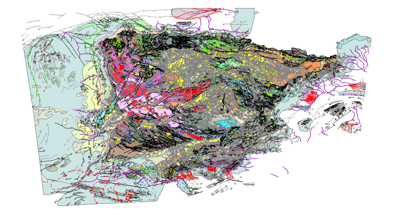
Geological Map of Spain and Portugal at scale 1:1.000.000
Geological map of Spain and Portugal at scale 1:1 000 000 of 2015 is an updated cartographic version of the Iberian Peninsula as well as Ceuta and Melilla and all the insular territory of Spain and Portugal: Balearic Islands, Canary Islands, Azores and Madeira, published periodically by the IGME in collaboration with the Geological Survey of Portugal (LNEG). This new version includes for the first time the geological cartography of the continental shelf and the Atlantic islands of Portugal. This map includes all the new geological knowledge that has resulted from the completion of the MAGNA series of 1:50,000 scale geological cartography of the IGME for the Spanish territory and the systematic series of cartography of the Portuguese territory developed by the LNEG. The continental part of the map has been composed from previous syntheses at a scale of 1:400,000 developed for each major geological unit in Spain, specifically, the Variscan Massif, the Pyrenees, the Baetic, Cantabrian and Iberian C. and the Cenozoic Basins of the Duero, Tagus and Ebro, and from the geological cartography at a scale of 1:200,000 produced in Portugal.
Simple
- Alternate title
-
Mapa Geológico de Espanha e Portugal à escala 1:1 000 00
- Date (Creation)
- 2015-12-17
- Edition
-
3ª Edición
- Citation identifier
- 26047 / ESPIGMEGEOLOGICO1000ESPANAYPORTUGAL
- Presentation form
- Hardcopy map
- Presentation form
- Digital map
- Purpose
-
This map represents an update of the geological cartography of the Iberian Peninsula and the entire island territory of Spain and Portugal at a scale of 1:1,000,000, as a synthesis of the improvement of geological knowledge that resulted from the completion of the MAGNA series of geological cartography at a scale of 1:50,000 of the IGME, for the Spanish territory, and the systematic series of cartography of the Portuguese territory developed by the LNEG. It includes for the first time the geological mapping of the continental shelf and that of the Portuguese Atlantic islands.
- Credit
-
Editores/Editors:L. Roberto Rodríguez Fernández (1) and J. Tomás Oliveira (2); Assistant editors: Fabián López Olmedo (1) and Ruben P. Dias (2); Editors of Continental shelf: Teresa Medialdea (1) and Pedro Terrinha (2); Authors of geológical map: L. R. Rodriguez Fernández (1), F. López Olmedo (1), J. T. Oliveira (2), T. Medialdea (1), P. Terrinha (2), J. Matas (1), A. Martín-Serrano (1), L. M. Martín Parra (1), F. Rubio (1), C. Marín (1), M. Montes (1) and F. Nozal (1); Authors of previous regional geological maps: Iberian Variscan Massif: J. L. Alonso (3), E. González Clavijo (1), N. Heredia (1), S. Lorenzo (4), F. López Olmedo (1), A. Marcos (3), L. M. Martín Parra (1), J. R. Martínez Catalán (5), J. Matas (1), J. T. Oliveira (2), E. Pereira (2), L. R. Rodríguez Fernández (1) and F. Rubio (1); Mesozoic and Cenozoic: R. Dias (2), F. López Olmedo (1), A. Martín-Serrano (1), M. Montes (1), F. Nozal (1), J. Pais (2), A. Pineda (6), J. Ramajo (1), M. Ramalho (2), A. Robador (1) and L. R. Rodríguez Fernández (1); Betic cordillera and rif: J. Galindo (7), A. Jabaloy (7), C. Marín (1), F. López Olmedo (1), A. Martín-Serrano (1), F. Roldán (1) e J. Rodríguez Fernández (8); Canary islands: J. L. Barrera (9) and F. Bellido (1); Igneous rocks: F. Bellido (1), M. L. Duarte (2), N. Ferreira (2), G. Gallastegui (1), L. González Menéndez (1) and F. Rubio (1); Continental shelf: T. Medialdea (1), P. Terrinha (2), L. Somoza (1), R. León (1), J. T. Vázquez (10), A. Maldonado (11) (8), R. Vegas (12), E. Llave (1), A. Maestro (1), P. Bárcenas (1), G. Ercilla (13) (8), M. C. Fernández Puga (1), F. J. González Sanz (1) and Instituto Hidrográfico da Marinha; Digital mapping: J. Vicente Ocaña (14), T. A. Cunha (2), A. Cabrera (1) and F. Pérez Cerdán (1); Digital edition: J. Vicente Ocaña (14); Edition control: G. Romero (1) and A. Diaz de Neira (1). (1)- Instituto Geológico y Minero de España; (2)- Laboratório Nacional de Energia e Geologia; (3)- Universidad de Oviedo; (4)- UCLM; (5)- USAL; (6)- EP; (7)- UGR; (8)- CSIC; (9)- ICOG; (10)- UCA; (11)- IACT; (12)- UCM; (13)- CMIMA; (14)- Edijesma
- Point of contact
-
Organisation name Individual name Electronic mail address Role Instituto Geológico y Minero de España (IGME-CSIC)
Publisher Laboratório Nacional de Energia e Geologia, I.P.
Point of contact
- Maintenance and update frequency
- Not planned
- Keywords
-
-
IGME
-
LNEG
-
Official Geological Cartography
-
Geological Map
-
infoMapAccessService
-
EGDI
-
-
EuropeanTerritorialUnits
-
-
España
-
Portugal
-
Balearic Islands
-
Canárias
-
Região Autónoma dos Açores
-
Região Autónoma da Madeira
-
-
IGME Thesaurus
-
-
General geology
-
Geology
-
Estratigrafía
-
Lithostratigraphy
-
Chronostratigraphy
-
Lithology
-
Systematics of metamorphic rocks
-
Metamorphic rock
-
rock
-
Crystalline rock
-
Igneous rock
-
Structural geology
-
Fault
-
Systematic Geography
-
Spain
-
Sedimentary rock
-
Boundary
-
Stratigraphy Systematics
-
Precambrian
-
Paleozoic
-
Mesozoic
-
Cenozoic
-
Quaternary
-
-
GEMET
-
-
NATURAL ENVIRONMENT, ANTHROPIC ENVIRONMENT
-
LITHOSPHERE (soil, geological processes)
-
lithosphere
-
rocks
-
- Stratum
-
-
Geological units
-
Geology
-
Ages
-
Faults
-
- Specific usage
-
The geological map of Spain and Portugal at 1:1 000 000 scale can be used as a tool for dissemination and teaching purposes. It also can be used as a reference publication about the Geology of Spain and Portugal for the elaboration of derived maps at the same scale as hydrogeological, natural hazards or mineral resources maps.
- User contact info
-
Organisation name Individual name Electronic mail address Role Instituto Geológico y Minero de España (IGME-CSIC)
Point of contact
- Use limitation
-
LICENCE OF USE: Conditions of public use and dissemination of information for the re-use of IGME data. http://www.igme.es/Ayuda/CondiUso.htm
- Access constraints
- Other restrictions
- Use constraints
- Other restrictions
- Other constraints
-
LICENCE OF USE: Conditions of public use and dissemination of information for the re-use of IGME data. http://www.igme.es/Ayuda/CondiUso.htm
- Spatial representation type
- Vector
- Denominator
- 1000000
- Language
- Spanish; Castilian
- Character set
- UTF8
- Topic category
-
- Geoscientific information
))
- Unique resource identifier
- EPSG:4258
- Unique resource identifier
- EPSG:3042
- Unique resource identifier
- EPSG:5013
- Unique resource identifier
- EPSG:5014
- Unique resource identifier
- EPSG:5015
- Unique resource identifier
- EPSG:5016
- Unique resource identifier
- EPSG:23030
- Unique resource identifier
- EPSG:3040
- Unique resource identifier
- EPSG:23028
- Distribution format
-
Name Version Shapefile (.shp) Unnkown
Servicio web: WMS - Web Map Service
1.3.0
Distributor
- Distributor contact
-
Organisation name Individual name Electronic mail address Role Instituto Geológico y Minero de España (IGME-CSIC)
Distributor
- Fees
-
Distribución a través de la web
- Distributor contact
-
Organisation name Individual name Electronic mail address Role Vicedirección Técnica de Sistemas de Información Geológica del Instituto Geológico y Minero del España (IGME-CSIC)
Distributor
- OnLine resource
-
Protocol Linkage Name Servicio de visualización WMS del Mapa Geológico de España y Portugal a escala 1:1.000.000
http://mapas.igme.es/gis/services/Cartografia_Geologica/IGME_EP_Geologico_1M_2018/MapServer/WmsServer?REQUEST=GetCapabilities&SERVICE=WMS WWW:LINK-1.0-http--link
http://info.igme.es/cartografiadigital/geologica/Geologicos1MMapa.aspx?Id=Geologico1000_(2015) Download the Geological Map of Spain and Portugal at scale 1:1.000.000
- Hierarchy level
- Dataset
Conformance result
Conformance result
Conformance result
- Title
-
Commission Regulation (EC) No 1205/2008 of 3 December 2008 laying down detailed rules for the implementation of Directive 2007/2/EC of the European Parliament and of the Council as regards metadata
- Date (Publication)
- 2008-12-04
- Explanation
-
Consult the regulation
- Pass
- Yes
- Statement
-
The Geological Map of Spain and Portugal at a scale of 1:1 000 000 was compiled from various sources. The continental part of the map was compiled from previous 1:400,000 scale syntheses prepared for each of the major geological units in Spain, namely the Variscan Massif, the Pyrenees, the Betic Cordillera, the Cantabrian and Iberian Cordillera and the basins of the Duero, Tagus and Ebro rivers, and the 1:200,000 scale geological cartography carried out in Portugal. A group of experts simplified this initial information and compiled it according to the common legend defined for the map. The mapping of the Spanish islands was elaborated from the original information of the IGME cartographic series at various scales and the geological mapping at scales 1:25 000 and 1:50 000 for the Portuguese Atlantic islands. The geological mapping of the continental margin was elaborated from several cartographic sources at different scales: Geological Maps of the Spanish Continental Shelf at scale 1:200 000 and the Geological Map of the Quaternary at scale 1:1 000 000 published by the IGME, the Geological Map of Portugal at scale 1:1 000 000 000 (LNEG-LGM) including the new version of the Geological Map of the Portuguese Continental Shelf at scale 1:2 000 000 000 and the Geological Map of the Bay of Biscay (BRGM). This cartography was complemented with geological data acquired in oceanographic campaigns carried out in the framework of different research projects with the participation of the IGME and the LNEG, as well as the Spanish Continental Shelf Expansion Project, in accordance with the United Nations Convention on the Law of the Sea.
- Description
-
Stage 1 - Compilation of cartographic information produced by the IGME and the LNEG, at different scales: 1:25.000, 1:50.000, 1:200.000 and 1:1.000.000 produced by the IGME and also at 1:500.000 scale by the LNEG..
- Description
-
Stage 2 - Preparation of cartographic syntheses at a scale of 1:400,000 for each of the major geological regions of Spain, namely: Variscan Massif, Pyrenees, Betic, Cantabrian and Iberian C. and the Duero, Tagus and Ebro basins, and synthesis of the geological cartography at a scale of 1:200,000 for Portugal.
- Description
-
Stage 3 - Adjustment and marriage of the different regions and cartographies (including at the border) creating the general legend and assembling the complete map.
- Description
-
Stage 4 - Adaptation of the cartography of the peninsular territory and the Balearic archipelago to the topographic base BCN1250 ETRS89, HUSO 30 of the National Geographic Institute.
- Description
-
Step 5 - Digitisation of the Atlantic island territories in their respective projections and zones, namely REGCAN95 UTM28N for the Canary Islands, AZORES CENTRAL 1995, UTM 28N projection for the Azores Archipelago and ITRF93, UTM 28N projection for the Madeira Archipelago..
- Description
-
Step 6 - The geology of the continental margin was generated in two blocks; Spanish and Portuguese shelf. The Spanish shelf was divided into 3 zones: Cantabrian, Mediterranean and Gulf of Cadiz in the ED50UTM30N projection, being imported into ArcGis v.10. The block of the Portuguese platform was delivered by the LNEG in Transverse Mercator Huso 31. For its assembly, all the information was projected to ERTRS89 UTM30N with ArcGis 10, adjusting the elements in continuity between both (Spanish and Portuguese part) and at the same time to both margins (platform and terrestrial).
- Description
-
Step 7 - Composition and layout of the printed version of the map made with MAPublisher v. 9 software for Adobe Illustrator CC2014 from files.
- Description
-
Stage 8 - Integration of the final information into an ArcGis v10 File Geodatabase and correction and adaptation to the INSPIRE data model.
- Description
-
The rock units of the sheet separated by different types of contacts are represented, together with the tectonic structure, faults and map traces of folds, the orientation and dip of planar and linear elements contained in the rocks, structural and textural singularities of igneous and metamorphic rocks, water points, mineral deposits and indications, presence of fossils and other elements of punctual representation..
- Denominator
- 50000
- Title
-
Geological Map of Spain at a scale of 1:50.000, 2nd Series, MAGNA (IGME)
- Date (Creation)
- 1971-01-01
- Description
-
The rock units of the sheet separated by different types of contacts are represented, together with the tectonic structure, faults and map traces of folds, the orientation and dip of planar and linear elements contained in the rocks, structural and textural singularities of igneous and metamorphic rocks, water points, mineral deposits and indications, presence of fossils and other elements of punctual representation.
- Denominator
- 200000
- Title
-
Geological Map of Spain at scale 1:200.000 (IGME)
- Date (Creation)
- 1980-01-01
- Description
-
Geological Map of the Spanish Continental Shelf at a scale of 1:200 000 (IGME)
- Denominator
- 200000
- Title
-
Geological Map of the Spanish Continental Shelf at a scale of 1:200,000 (IGME)
- Date (Creation)
- 2000-01-01
- Description
-
Geological Map of Catalonia, scale 1:250 000
- Denominator
- 250000
- Title
-
Geological Map of Catalonia, scale 1:250 000
- Date (Creation)
- 2002-09-01
- Description
-
Geological Mining Map of Andalucia 1:400.000
- Denominator
- 400000
- Title
-
Geological Mining Map of Andalucia 1:400.000
- Date (Creation)
- 1985-09-01
- Description
-
Geological Map of Portugal at a scale of 1:500 000 (SGP, 1992)
- Denominator
- 500000
- Title
-
Geological Map of Portugal at a scale of 1:500 000 (SGP, 1992)
- Date (Creation)
- 1992-09-01
- Description
-
Geological Map of the Iberian Peninsula, Balearic and Canary Islands, scale 1:1 000 000, 1995 edition.
- Denominator
- 1000000
- Title
-
Geological Map of the Iberian Peninsula, Balearic and Canary Islands, scale 1:1,000,000, 1995 edition.
- Date (Creation)
- 1995-01-01
- Description
-
Geological Map of Portugal at scale 1:1 000 000 (LNEG-LGM, 2010)
- Denominator
- 1000000
- Title
-
Geological Map of Portugal at scale 1:1 000 000 (LNEG-LGM, 2010)
- Date (Publication)
- 2010-01-01
- Description
-
The Map contains the chronolithostratigraphic units separated by undifferentiated geological contacts and the tectonic structure represented by faults and thrusts.
- Denominator
- 1000000
- Title
-
Geological map of France 1:1 000 000, 6th edition
- Date (Publication)
- 1996-04-01
- Description
-
The Map contains the chronolithostratigraphic units separated by undifferentiated geological contacts and the tectonic structure represented by faults and thrusts.
- Denominator
- 1000000
- Title
-
Geological Map of Morocco
- Date (Publication)
- 1985-04-01
- Description
-
The map shows the chronostratigraphic units bounded by undifferentiated geological boundaries and the geological structure represented by faults and thrusts.
- Denominator
- 200000
- Title
-
Geological Map of Spain at scale 1: 2 000 000
- Date (Publication)
- 2004-01-01
Metadata
- File identifier
- ESPIGMEGEOLOGICO1000ESPANAYPORTUGAL20180427 XML
- Metadata language
- Spanish; Castilian
- Character set
- UTF8
- Hierarchy level
- Dataset
- Date stamp
- 2025-05-09T07:17:28.366743Z
- Metadata standard name
-
Reglamento (CE) Nº 1205/2008 de Inspire, "Perfil IGME"
- Metadata standard version
-
TG 2.0
- Metadata author
-
Organisation name Individual name Electronic mail address Role Instituto Geológico y Minero de España (IGME-CSIC)
Leticia Vega Martín
Point of contact
- Other language
-
Language Character encoding English UTF8 Spanish; Castilian UTF8
)))