 Catalogo de metadatos IGME-CSIC
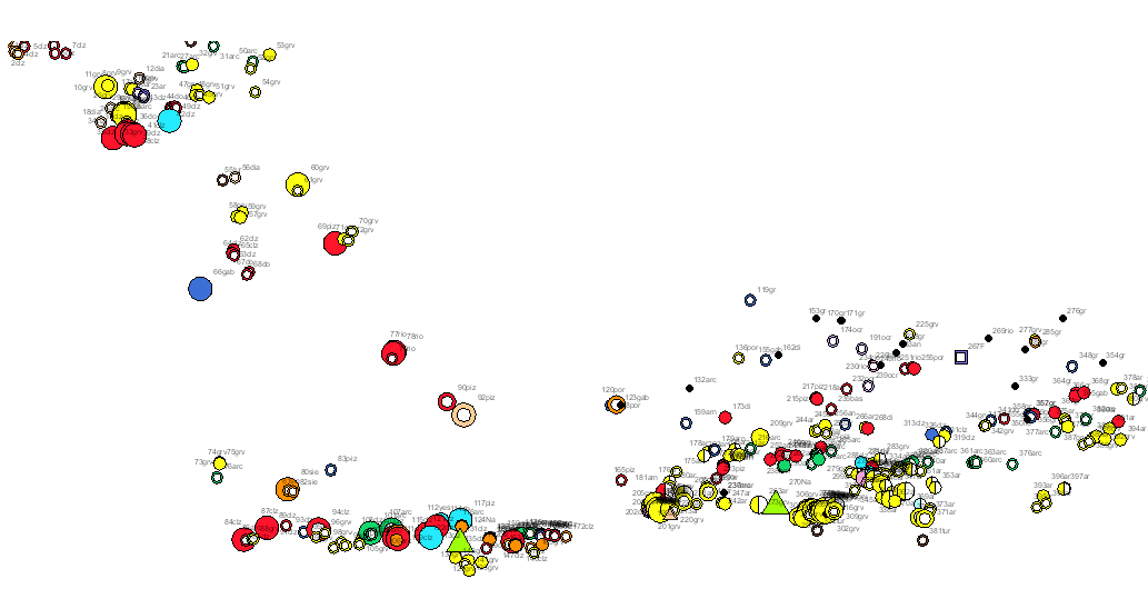
Map of rocks and industrial minerals of the South Portuguese Zone. Scale 1:400.000. 2020 edition.
Rocks and industrial minerals map of the South Portuguese Zone in which on the harmonized geological base, with unified criteria between Spain and Portugal, the main non-metallic mineral occurrences and nonmetallic and industrial mineral mines in the area have been represented , indicating its status (active, abandoned or intermittent), size, use and substance. This cartography is a product resulting from the GEO_FPI project: GEO_FPI: cross-border observatory for the geo-economic evaluation of the Iberian Pyrite Belt, financed by the European Regional Development Fund (ERDF) within the program INTERREG V-A Spain– Portugal (POCTEP) 2014-2020. The main beneficiary of the project is the Geological Survey of Spain (IGME-CSIC). Additionally, the General Directorate of Industry, Energy and Mines of the Ministry of Employment, Enterprise and Commerce of the Andalusian Government (JA) and the Portuguese National Laboratory for Energy and Geology (LNEG) and the Municipal Chamber of Aljustrel (CMA) are partners of the project.
Simple
- Alternate title
-
GEO_FPI_ROCAS_MINERALES_INDUSTRIALES400
- Date (Creation)
- 2020-06-01
- Date (Publication)
- 2020-06-01
- Citation identifier
- / ESPIGMEROCASMINERALESINDUSTRIALES400
- Purpose
-
Providing information about the mining operations and deposit of industrial rocks and minerals present in the Geological Domain of the South-Portuguese Zone (SPZ) and SW Iberia Mesozoic and Cenozoic basins. The information focuses on the type of mineral commodity, the state of the activity and magnitude, and the destination of the resource.
- Credit
-
DIRECTION AND COORDINATION: Manuel Vázquez Mora and José Javier Almarza López (SGIEM); Manuel Ruiz-Montes, Ángel García-Cortes and María Teresa López López (IGME-CSIC)
IGME Authors: Vitorio Monteserín López and Javier Marimón Lominchar.
Authors LNEG: Jorge Carvlho, Sara Santos and João Xavier Matos.
Geological Cartography (IGME-CSIC): Paleozoic: Alejandro Díez-Montes; Mesozoic and Cenozoic: Juan Julián Huerta Carmona.
GIS: Ana Sevillano Matilla, Marta Criado Valdés (eGeoMapping).
Geological Mapping (LNEG): Palaeozoic: João Xavier Matos, Luís Albardeiro, José T. Oliveira, Igor Morais, Paulo Fernandes, Carlos Inverno; Mesozoic: Susana Machado; Cenozoic: Ruben Dias, Ricardo Ressurreição.
GIS: Sara Santos, Pedro Gonçalves.
Project coordination: María Teresa López López (IGME-CSIC).
- Status
- Completed
- Point of contact
-
Organisation name Individual name Electronic mail address Role Geological Survey of Spain (IGME-CSIC)
Mª Teresa López López
Principal investigator National Energy and Geology Laboratory, I.P. (LNEG)
João Xavier Matos
Author
- Maintenance and update frequency
- Not planned
-
IGME Thesaurus
-
-
Alentejo
-
Algarve
-
Andalusia Andalucia
-
Cartography Cartografia
-
Geology Geologia
-
Chronostratigraphy
-
Mineral localities
-
Massive sulfide deposits
-
Mines
-
Quarries
-
Spain
-
Portugal
-
- Keywords
-
-
400K
-
- Keywords
-
-
Mines
-
- Keywords
-
-
Metallogenetic map
-
- Keywords
-
-
Industrial rocks and minerals
-
- Keywords
-
-
Iberian Pyritic Belt
-
- Keywords
-
-
Surportuguese zone
-
- Keywords
-
-
IGME
-
- Keywords
-
-
LNEG
-
- Keywords
-
-
EGDI
-
- Specific usage
-
Geological mapping, mineral resource research, mining, natural resources, environment, geology, industrial rocks and minerals
- User contact info
-
Organisation name Individual name Electronic mail address Role Spanish Geological Survey (IGME-CSIC)
Point of contact
- Access constraints
- Other restrictions
- Other constraints
- No limitations on public access.
- Use constraints
- Other restrictions
- Other constraints
-
LICENCE OF USE: Conditions of public use and dissemination of information for the re-use of IGME data. http://www.igme.es/Ayuda/CondiUso.htm
- Use constraints
- Other restrictions
- Spatial representation type
- Vector
- Denominator
- 400000
- Language
- Spanish; Castilian
- Character set
- UTF8
- Topic category
-
- Geoscientific information
))
- Extent type code
- Yes
- Geographic identifier
- ES
- Unique resource identifier
- EPSG:3857
- Unique resource identifier
- CRS:84
- Unique resource identifier
- EPSG:4258
- Unique resource identifier
- EPSG:4326
- Unique resource identifier
- EPSG:4230
- Unique resource identifier
- EPSG:23028
- Unique resource identifier
- EPSG:23029
- Unique resource identifier
- EPSG:23030
- Unique resource identifier
- EPSG:23031
- Unique resource identifier
- EPSG:25828
- Unique resource identifier
- EPSG:25829
- Unique resource identifier
- EPSG:25830
- Unique resource identifier
- EPSG:25831
- Unique resource identifier
- EPSG:102100
- Distribution format
-
Name Version SHP (uso restringido)
No se aplica
Web Map Service WMS
1.3.0
Mapa digital: PDF - Portable Document Format
-
Joint Photographic Group Format JPEG
No se aplica
Tagged Image File FormatTIFF
No se aplica
Distributor
- Distributor contact
-
Organisation name Individual name Electronic mail address Role Geological Survey of Spain (IGME-CSIC)
Distributor
- Fees
-
Distribución a través de la web
- Distributor contact
-
Organisation name Individual name Electronic mail address Role Technical Vice-Directorate of Geological Information Systems of the Geological Survey of Spain (IGME-CSIC)
Distributor
- OnLine resource
-
Protocol Linkage Name OGC:WMS-1.3.0-http-get-capabilities
http://mapas.igme.es/gis/services/GeoFPI/GEOFPI_ROCAS_MINERALES_INDUSTRIALES400/MapServer/WMSServer?request=getcapabilities&service=wms&version=1.3.0 WMS visualisation service of the Map of Industrial Rocks and Minerals of the South Portuguese Zone at 1:400.000 scale.
WWW:LINK-1.0-http--link
http://mapas.igme.es/gis/rest/services/GeoFPI/GEOFPI_ROCAS_MINERALES_INDUSTRIALES400/MapServer ArcGIS Server service of the Map of Industrial Rocks and Minerals of the South Portuguese Zone at 1:400.000 scale.
http://info.igme.es/catalogo/ Search of the Map of Industrial Rocks and Minerals of the South-Portuguese Zone at 1:400.000 scale in the project Geo_FPI - Cross-border Observatory for the geo-economic valorisation of the Iberian Pyritic Belt.
- Hierarchy level
- Dataset
Conformance result
Conformance result
- Title
-
Reglamento (CE) n.o 1205/2008 de la Comisión de 3 de Diciembre de 2008 que estabelece las modalidades de aplicación de la Directiva 2007/2/CE del Parlamento Europeo y del Consejo em materia de metadados
- Date (Publication)
- 2008-12-04
- Explanation
-
Consult the regulation
- Pass
- Yes
- Statement
-
Rocks and industrial minerals map of the South Portuguese Zone in which on the harmonized geological base, with unified criteria between Spain and Portugal, the main non-metallic mineral occurrences and nonmetallic and industrial mineral mines in the area have been represented , indicating its status (active, abandoned or intermittent), size, use and substance.
Metadata
- File identifier
- ESPIGMEGEOFPIROCASMINERALESINDUSTRIALES40020201114 XML
- Metadata language
- Spanish; Castilian
- Character set
- UTF8
- Hierarchy level
- Dataset
- Date stamp
- 2025-05-26T12:53:15.895331Z
- Metadata standard name
-
Reglamento (CE) Nº 1205/2008 de Inspire, "Perfil IGME"
- Metadata standard version
-
2.0
- Metadata author
-
Organisation name Individual name Electronic mail address Role Instituto Geológico y Minero de España (IGME-CSIC) Geological Survey of Spain (IGME-CSIC)
Leticia Vega Martín
Point of contact
- Other language
-
Language Character encoding English UTF8 Portuguese UTF8 Spanish; Castilian UTF8
)))